Property Record
1011 Par Makers Rd, Bowling Green, KY 42101
NEARBY LISTINGS FOR SALE OR LEASE
Property Detail
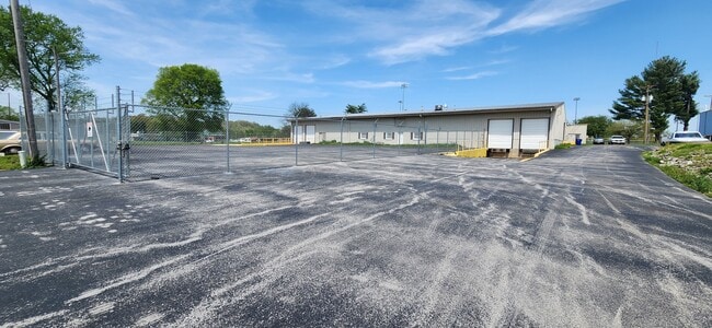
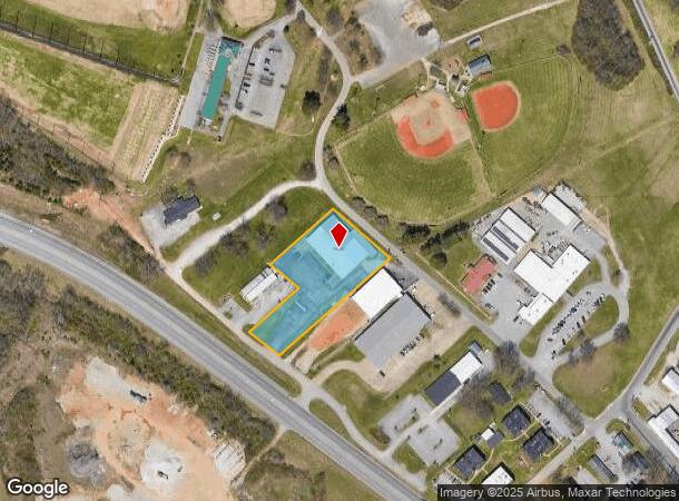
1011 Par Makers Rd
Residentialacreage
Warren
X
Kentucky
21227C0164E
1.56 AC
2025
Bowling Green Area
2025
Other Market Areas
010200
Bowling Green, KY
16,833 SF
039B-10-070
DEMOGRAPHICS near 1011 Par Makers Rd
1 Mile
3 Mile
5 Mile
2024 Total Population
6,242
41,562
80,118
2029 Population
6,945
45,462
88,069
Pop Growth 2024-2029
+ 11.26%
+ 9.38%
+ 9.92%
Average Age
34
34
35
2024 Total Households
2,253
15,330
31,592
HH Growth 2024-2029
+ 11.94%
+ 10.35%
+ 10.65%
Median Household Inc
$27,366
$36,706
$44,929
Avg Household Size
2.60
2.30
2.30
2024 Avg HH Vehicles
1.00
2.00
2.00
Median Home Value
$90,920
$166,017
$195,985
Median Year Built
1974
1976
1987
Nearby Places
Map Layers
Map Styles
 Street
 Aerial
- Restaurants
- Banks
- Shops
- Fitness
- Groceries
SALE & LEASE HISTORY
LISTING DATE
SALE/LEASE

Apr 23, 2024
For Lease
Nearby Properties
Address
Land Use
TOTAL SIZE
Lot Size
Zoning
Address
Land Use
TOTAL SIZE
Lot Size
Zoning
117,551 SF
5.06 AC
Address
Land Use
TOTAL SIZE
Lot Size
Zoning
150,327 SF
2.54 AC
Address
Land Use
TOTAL SIZE
Lot Size
Zoning
36,984 SF
7.26 AC
Address
Land Use
TOTAL SIZE
Lot Size
Zoning
93,730 SF
4.05 AC
Address
Land Use
TOTAL SIZE
Lot Size
Zoning
19.61 AC
Address
Land Use
TOTAL SIZE
Lot Size
Zoning
214,273 SF
26.97 AC
Address
Land Use
TOTAL SIZE
Lot Size
Zoning
Address
Land Use
TOTAL SIZE
Lot Size
Zoning
Address
Land Use
TOTAL SIZE
Lot Size
Zoning
2,946 SF
3.59 AC
Address
Land Use
TOTAL SIZE
Lot Size
Zoning
176,450 SF
18.60 AC
Address
Land Use
TOTAL SIZE
Lot Size
Zoning
1,101 SF
16.07 AC
Address
Land Use
TOTAL SIZE
Lot Size
Zoning
3,200 SF
8.61 AC
Address
Land Use
TOTAL SIZE
Lot Size
Zoning
3,120 SF
4.97 AC
Address
Land Use
TOTAL SIZE
Lot Size
Zoning
13,277 SF
1.21 AC
Address
Land Use
TOTAL SIZE
Lot Size
Zoning
13,661 SF
6.25 AC
Address
Land Use
TOTAL SIZE
Lot Size
Zoning
43,663 SF
8.77 AC
Address
Land Use
TOTAL SIZE
Lot Size
Zoning
159,256 SF
11.44 AC
Address
Land Use
TOTAL SIZE
Lot Size
Zoning
62,052 SF
6.03 AC
Address
Land Use
TOTAL SIZE
Lot Size
Zoning
27,100 SF
8.43 AC
Address
Land Use
TOTAL SIZE
Lot Size
Zoning
4,608 SF
8 AC
Address
Land Use
TOTAL SIZE
Lot Size
Zoning
Address
Land Use
TOTAL SIZE
Lot Size
Zoning
208,988 SF
13.64 AC
Address
Land Use
TOTAL SIZE
Lot Size
Zoning
47,001 SF
5.03 AC
Address
Land Use
TOTAL SIZE
Lot Size
Zoning
90,196 SF
12.44 AC
Address
Land Use
TOTAL SIZE
Lot Size
Zoning
46,672 SF
1.45 AC
Address
Land Use
TOTAL SIZE
Lot Size
Zoning
4,576 SF
6.26 AC
Address
Land Use
TOTAL SIZE
Lot Size
Zoning
204,696 SF
14.30 AC
Address
Land Use
TOTAL SIZE
Lot Size
Zoning
8,134 SF
1.64 AC
Address
Land Use
TOTAL SIZE
Lot Size
Zoning
18,666 SF
0.86 AC
Address
Land Use
TOTAL SIZE
Lot Size
Zoning
6,993 SF
0.64 AC
The World's #1 Commercial Real Estate Marketplace
Connect with us
© 2026 CoStar Group
The information above has been obtained from sources believed reliable. While we do not doubt its accuracy we have not verified it and make no guarantee, warranty or representation about it. It is your responsibility to independently confirm its accuracy and completeness. Any projections, opinions, assumptions, or estimates used are for example only and do not represent the current or future performance of the property. The value of this transaction to you depends on tax and other factors which should be evaluated by your tax, financial, and legal advisors. You and your advisors should conduct a careful, independent investigation of the property to determine to your satisfaction the suitability of the property for your needs.